A round trip from the Hoendiep to the Leekstermeer and Onlanden: 25 km. (GPS-track). There are two portages in the route.
Kayak rentals:
- Dorpshuis Watersportcentrum Lettelbert.
- Natuurcamping Lettelbert.
- Watersportcentrum Cnossen Leekstermeer.
Starting point Hoendiep
Exit the A7 (Heerenveen - Groningen) at exit 34a Westpoort. At the third roundabout you turn left towards Enumatil. You drive along the Hoendiep passed De Poffert. After 2 km you turn left. The starting point is just across the bridge on your right. There is a picnic table and a kayak pier.Alternative starting point at Nienoordshaven in Leek
At this starting point there is limited parking space.Exit the A7 at exit 24 towards Leek. At the second roundabout you turn left in the direction Roden. At the next roundabout you turn right, and then turn left. You keep left and the turn left. Before the marina you turn right. You can park on the right near the slipway. The kayak pier is a little further on the corner.
From here you follow the canal to the Leekstermeer, and then turn right.
Round trip of 25 km. (GPS-track)
From the starting point Hoendiep you go to the left (west). At the end of the canal you turn left on the Lettelberterdiep. (The GPS-track makes a small detour to the right towards Enumatil) You pass under the A7 and at the trees you see the camping Lettelbert on the right. A little further you come at the Leekstermeer. You cross the canal to the right and follow the right shore. In the corner you see recreation area Cnossen. There is a restaurant and an area for swimming. You enter the canal on the right. At a pumping station you portage to the Molensloot. There are low sides so it's easy to get on the side. After a bend to the left the canal is named Bolmertsche Schouwe. Follow the canal and enjoy the silence. At the end of the canal you turn left on the wider Rodervaart. After a short distance you come at the Leekstermeer. You cross the lake and follow de reed on the right. The water becomes narrower and at a solar panel you turn right through a narrow passage to the Onlanden. Follow the canal and at a T-junction you turn left on the canal Blenkewijk. At the end of the canal you portage to the Peizerdiep. There are good kayak-piers. You turn left on the Peizerdiep towards Vierverlaten. After a railroad bridge you can turn right for a visit of Hoogkerken. You pass the sugar factory of the Cosun Beet Company. There is an impressive structure with lots of pipes. You pass under a low bridge. At the next bridge there is a kayak-pier. There is a snackbar and a supermarket. Parking here is allowed for only 2 hours, so this is not a good starting point for a long kayak trip. You return passed the factory and then turn right on the wider Aduarderdiep. After 2 km. you turn sharp left. Pass the houseboats at Nieuwbrug. After the railroad bridge there is a kayak pier on your right with a picnic table. You can also go for a swim here. At De Poffert you pass through a low culvert and then you turn right twice to the Hoendiep.
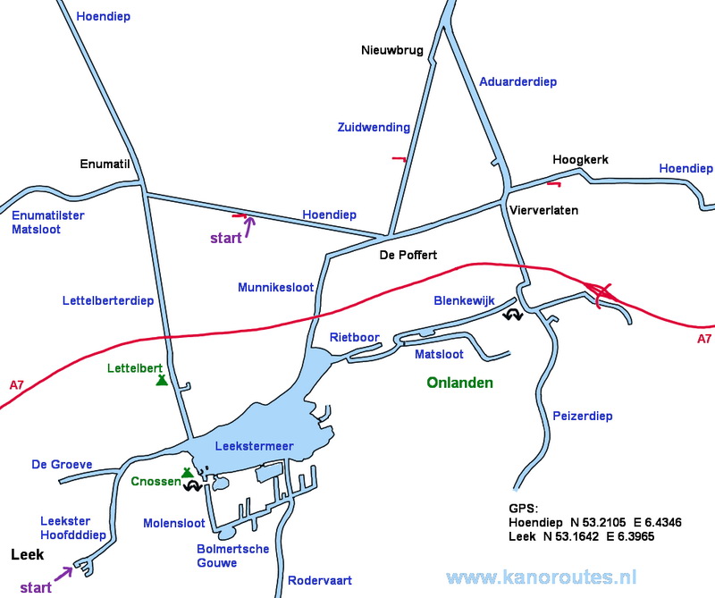
GPS Hoendiep: N 53.2105 E 6.4346 Leek: N 53.1642 E 6.3965

Downloadable GPS-track 25.4 km: Leekstermeer.gpx

Enumatil.

Lettelberterdiep.

Lettelbert.

Watersportcenter Cnossen.

Bolmertsche Gouwe.

Rodervaart.

Passage from the Leekstermeer to the Onlanden. Turn right at the solar panel.

The Onlanden.

Peizerdiep towards Vierverlaten.

Sugar factory of the Cosun Beet Company near Hoogkerk.

Sugar factory.

Kayak pier at the bridge in Hoogkerk. There is a snackbar and a supermarket.

Horses along the Zuidwending.

Low passage at De Poffert.

Starting point along the Hoendiep.